

Up, Up and Away Over Ancient Thebes
/My friend Cathy and I get up at 4:00 a.m., hop on a van that takes us to a boat across the Nile, then join a convoy of vans to the launch site. As mosquitoes feast on us in the vast, dark field, we meet our pilot who is waiting with his ground crew next to his collapsed balloon. He warns us that because we are right next to a military facility, cameras are not allowed. Cell phones are fine, but if you’re caught using your camera on the ground, they could confiscate it. What a bummer. I reluctantly put my camera away and use my cheap cell phone to take pictures while we’re still on the ground.
After swatting bugs for almost an hour, we get the go-signal. Amid booming cheers on the launch site, the ground crews light the fires and the balloons begin inflating. Giddy with excitement, I can hardly wait to be told it’s now okay to board.

Taking off with my friend Cathy and our pilot in a hot air balloon as the sun rises over Luxor and the Theban Necropolis (Photos by Odette Foronda)
Soon after out balloon gets off the ground, our pilot asks everyone if it’s our first balloon ride. When most of us say yes, he says, “Me, too!” I forget his name, so I’ll call him Sindbad after the name of the balloon company. He goes on to explain that the only things he has the ability to control are the altitude and vertical speed of the balloon, by regulating the burners; otherwise, we are at the mercy of the wind. Below us, the rising sun bathes the landscape with a warm glow. Quite stunning. Green fields, a glimpse of the Blue Nile, and a stark, stony mountain that is ancient Thebes’ fabled city of the dead.
Sindbad says, “Look, look, the Valley of the Kings…Hatshepsut’s Temple…” Having done some pre-trip research, I easily locate the temple. As well, I remember that back in 1997, six terrorists disguised as members of the site’s security forces massacred 62 people, mostly tourists, inside that temple. Sixty-two. Too late to worry about dangers now. While many of my co-passengers are busy shooting selfies left and right, I pester Sindbad by rattling off the places we are set to visit with Mac afterward: “Medinet Habu, where? The Memnon statues…” And gamely he says, “Right below us, there’s Memnon, my grandfather.”
Finally free to use my camera, I click away. Here’s a shot I took of the Theban Necropolis from up, up and away in Sindbad’s beautiful balloon.

Ancient Thebes, now part of the modern city of Luxor, was once a capital of Egypt. The Theban Mountains on the west bank of the Nile were used as a necropolis for about 500 years and the entire area is now a UNESCO World Heritage site. (Photo by Odette Foronda)
Because I’m no Egyptologist, I can hardly wrap my head around the complicated story of Egypt that spans as much as 10,000 years. I try to do it in very broad strokes. It helps that historians have sorted its long list of rulers into dynasties and have classified eras into kingdoms and intermediate periods. They call periods of stability and prosperity kingdoms and periods of political strife or instability intermediate periods. The Nile has largely dictated Egypt’s fortunes, and political divisions have time and again been between Upper Egypt and Lower Egypt, labels based on geographical locations with respect to the Nile. The Nile flows northward and empties to the Mediterranean. The upstream section, in the south, is called Upper Egypt, while downstream is called Lower Egypt. And so, to enhance my confusion, a conventional map will show Upper Egypt below Lower Egypt.
The Old Kingdom (3100-2180 BC) covers almost a thousand years, when kings built pyramids to signify their divine power and to serve as their stairways to heaven. For most of this time, the kingdom’s capital was Memphis near modern-day Cairo. After centuries of pyramid-building, royal power declined. The succeeding six hundred years (2180-1550 BC) was a mix of stability and civil wars and are labeled the First Intermediate Period, Middle Kingdom, and Second Intermediate Period. It was during this time (2055 BC) when the southern city of Thebes became the seat of power of a monarchy founded by Montuhotep II of the 11th dynasty. It remained the capital of Egypt for almost three hundred years during the Middle Kingdom. During the Second Intermediate Period, Egypt was divided and was governed by minor rulers who chose various locations as their capitals.
The New Kingdom started when Upper and Lower Egypt were united once more. It spans close to five hundred years, 1550-1069 BC, and is regarded as Egypt’s Golden Age with a long list of powerful kings that turned the country into the superpower of the ancient world, with names like Ramesses II (aka Ramesses the Great), Hatshepsut, Amenhotep, Seti. Once again, the kingdom’s capital was Thebes, whose ruins now lie beneath modern-day Luxor.
Just to complete the BC timeline, the New Kingdom was followed by the Third Intermediate Period, the Late Period, and finally the Ptolemaic Period, which started with Alexander the Great and ended with Cleopatra.
In their grandiosity and ostentation, all the pyramids were robbed of their treasures. Even most of the mummies went missing for the amulets embedded in their linen bandages. Keeping royal tombs safe from looters was probably why later kings chose instead to be buried in secluded rock-hewn tombs like those in Thebes’ Valley of the Kings. Apart from being on a high-altitude, hidden gorge, the location was likely chosen because it’s right below a pyramid-shaped peak, a shape that had long been regarded as a symbol of rebirth and eternal life. In the end, most of the 60-odd tombs in this valley were plundered anyway, with the exception of only a handful, most notable of which is the tomb of the boy-king Tutankhamun, which was discovered intact by Howard Carter in 1922.
Just like the Pyramids, the royal rock-cut tombs were resurrection machines, designed to aid the spirit of the pharaoh in its journey to the afterlife. A tomb’s entrance is usually a shaft cut into the hillside, sloping steeply downward either as a ramp or a stairway. Some tombs have vertical shaft entrances, and you’d wonder how they brought the sarcophagus to the burial chamber down below. There are usually side chambers used to hold items to ensure a comfortable afterlife for the deceased, some of which were used for magic rituals like figurines of deities and of the king’s family and servants. The walls and ceilings are mostly decorated with religious and funerary hieroglyphic texts and images meant to aid the deceased in his journey to the afterlife.
Tombs
For a closer look, let’s get off the balloon and let me take you down, and further down, to the bowels of the mountain. Archaeologists have so far catalogued 65 tombs in the Valley of the Kings, prefixing their labels with KV (or QV for the Valley of the Queens). King Tut’s tomb is KV62, while that of Ramesses VI is KV9; being the grandest, they require a special ticket on top of the general entrance ticket, which allows entry to at most three tombs. We’ll have to do a lot of walking under the punishing Egyptian sun, the kind that has your sweat crawling down your spine until you’re all sticky and drenched. And once inside a tomb, it’ll feel quite stuffy with a horde of other tourists that you’ll want to shoo away so you can take good photos. They’ll want to shoo you away, too, for sure. At some points, you’ll decide to skip some parts because of the oppressive heat and the crowds; maybe you’ll even say you’re done after just one tomb. But when you look back after you’ve freshened up and rested, I’m pretty sure you’ll be happy with what you’ve seen.

Top row: The Valley of the Kings is in a secluded gorge on a high plateau, directly below the pyramid-shaped peak named Al-Qurn. The paved road from the visitor center stretches for about two kilometers to the central part of the valley from where most tombs can be accessed. Golf carts are available for a certain portion of the road.
Middle and bottom row photos are from KV8, the Tomb of Merenptah, a son of Ramesses II. Watch your step, and your head, as you go down the 160-meter-long steep corridor, but remember to look at the walls and ceilings. (Photos by Odette Foronda)

Inside the Tomb of Merenptah (KV8), Valley of the Kings: detail of reliefs and the vaulted burial chamber with the stone sarcophagus and a niche that held precious statues of different deities. There are actually three other sarcophagi nested inside the visible one. The niche is decorated with chapters from the Book of Gates. (Photos by Odette Foronda)

Inside the Tomb of Ramesses III (KV11), Valley of the Kings (Photos by Odette Foronda)
The Valley of the Queens is similar to the Valley of the Kings, except that it contains tombs of queens as well as royal children. Expectedly, there are many more, but simpler, tombs here than in the Valley of the Kings.

Top row: The Valley of the Queens is at a lower elevation than the Valley of the Kings, although it also requires a considerable amount of walking. No golf carts here. Middle row: inside the Tomb of Prince Amonchopeshfu.
Bottom row: inside the Tomb of Prince Kha M Waset (QV44) (Photos by Odette Foronda)
Workmen’s Village
Okay, enough claustrophobia and climbing down shafts and climbing back up again. Let’s wash our hands, wipe our sweat, blow the moistened desert dust from our noses, hydrate, have a little snack. Then we go back under the scorching sun to explore what remains of the village that housed the builders of the royal tombs in the area, the Deir el-Medina or Workmen’s Village.
The village is on the lower slopes of the mountain, closer to the Nile as a water source but isolated from the wider population, presumably for secrecy. The ruins of the stone-and-mudbrick houses are dwarfed by a walled structure that used to be a temple to the goddess Hathor and was later converted to a Coptic church. The workmen built their own tombs following the same concepts that they applied in the royal tombs, maybe even using spare materials. Tombs were also rock-cut but much simpler and were adorned with a small pyramid above the ground.
Right next to the cluster of houses, archaeologists uncovered a deep pit that contained broken pottery - the village dump. These pieces, called ostraca, contained etchings. In those days, people used broken pottery as a writing surface, their version of our Post-It Notes. Around five thousand ostraca were found in that deep pit, pieces that contained information about daily life -- poetry, art, love notes, grievances, medical procedures, gossip, business matters, recipes, etc. Archaeologists painstakingly sorted these out and yielded impressive documentation of community life in the ancient world.

Top row, left and middle: Views of Deir el-Medina from the air and from the ground. The houses were built close together. The enclosed structure was a temple that was later converted into a Coptic Church. Rightmost photo: Next to the village is a deep pit where ostraca (broken pottery) were found.
Middle row: reliefs on the temple walls – one shows the fertility God Min’s erect phallus which was defaced during the Christian era; another an offering of donuts or bagels, grapes, chicken, etc.
Bottom left: Egyptologist Mahmoud Eid Abdelkader (aka Mac) explaining the significance of the art on the temple walls. Middle and rightmost: pyramid-shaped tomb of an official named Sennutem; wall decoration in the tomb of a workman named Anherkha
(Photos by Odette Foronda)
Mortuary Temples
The rest of the structures in the Theban Necropolis were mortuary temples.
In the days of the pyramids, the remains of the deceased ruler were kept inside the pyramid. Adjacent to the pyramid, there would be a temple built to commemorate the king’s life. Because a king was regarded as a demigod, the temple also served as a place to worship him after his death and until the end of time. Every single day, priests performed funerary rites and presented offerings to the dead ruler. Because it was meant to be forever, a mortuary temple was big business.
In Theban Necropolis, the mortuary temples were built away from the tombs, closer to the Nile and the wider population, and were great displays of power and wealth.
Remember our Middle Kingdom guy Montuhotep II? Twenty-first century BC, 11th dynasty. He was the one who first established Thebes as the capital of a united Egypt. He built himself a mortuary temple complex on a site called Deir el-Bahari. But because forever never comes easy, even for demigods, his temple is no more.
Five hundred years after Montuhotep II, Hatshepsut of the 18th dynasty built a grand mortuary temple on the ruins of Montuhotep II’s. Due to differing politics and grudges, the temple was defaced by succeeding rulers aiming to obliterate references to Hatshepsut’s rule. Part of what’s visible today is restoration of fragments retrieved from the site.
Many experts claim that Hatshepsut was a female ruler who had herself depicted as a bearded male in order to be more acceptable in a man’s world. However, many others disagree. Our Egyptologist guide Mac likes to say, “Egyptology is the science of maybe.” He tells us to look at the statues lining the colonnades, all Hatshepsut’s, and figure out for ourselves whether we see a she or a he. There are also speculations that Hatshepsut was gay and/or that one of his/her high officials was his/her lover. Royal gossip. Look up the name Senenmut and tell me what you find.

The Mortuary Temple of Hatshepsut carved out of the cliff. The aerial view (top left) shows the ruins of Montuhotep II’s temple to the left of Hatshepsut’s. Behind the cliff is the Valley of the Kings, where Hatshepsut’s tomb is located and labeled KV20. (Photos by Odette Foronda)
Let’s see a few more mortuary temples.
Ramesses II or Ramesses the Great, 19th dynasty – where’s his tomb? It is KV7 in the Valley of the Kings, next to KV8, the tomb of his son, Merenptah, which we entered earlier. Unfortunately, KV7 is not well-preserved due to repeated flooding over the centuries. As for his mortuary temple, Ramesses the Great built the Ramesseum on the Theban Necropolis. Just like Montuhotep II’s, this temple did not see forever and is largely in ruins.
Because they are huge and are located next to a highway, the two giant statues called the Colossi of Memnon are what tourists will first notice when they visit the west bank by land. They are what remain of a huge mortuary temple built around 1350 BC by King Amenhotep III of the 18th dynasty, almost a century after Hatshepsut.
So, who was Memnon whom Sindbad claims to be his grandpa?
The Greeks and the Romans came to Egypt over a thousand years later, and by then, Amenhotep III’s mortuary temple had mostly been wiped out by floods or plundered for building material by succeeding pharaohs. The twin statues that used to guard the temple survived, although they were damaged by earthquakes. They became a popular tourist attraction because one of them emitted a sound at sunrise, which sound is attributed by science to cracks in the stone. The Romans called the singing statue Memnon, the name of a son of the dawn goddess Eos, because Memnon was known to greet his mom with a sigh each morning. The singing stopped after the Roman emperor Septimius Severus had the cracks repaired, but the name Memnon has stuck to this day.
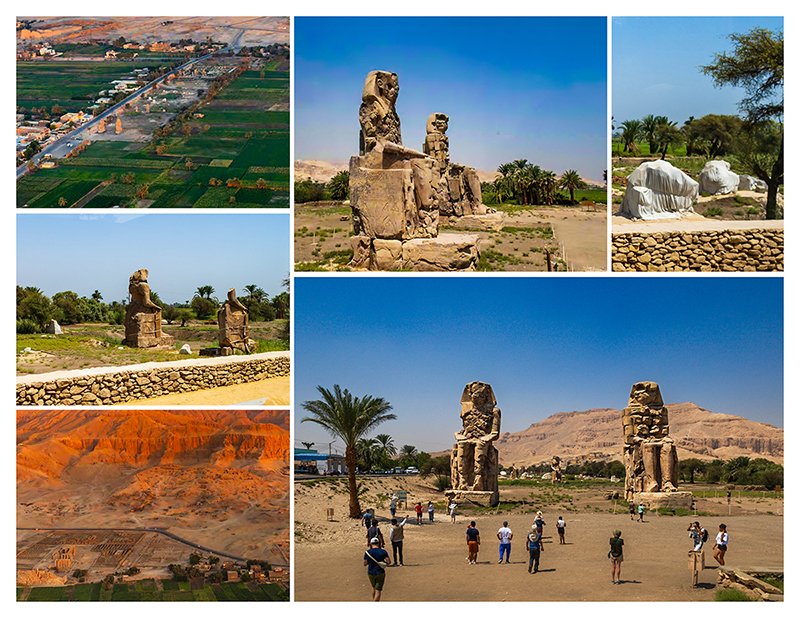
Bottom left: The Ramesseum on the foreground and the Tombs of the Nobles dotting the slope behind it. The rest of the photos are of the Colossi of Memnon complex, which used to be a gigantic mortuary temple of Amenhotep III. It is an active archaeological site, showing wrapped recent finds.
(Photos by Odette Foronda)
Medinet Habu. I have to thank Mac for convincing me to join the optional tour to this site (as well as to the Valley of the Queens and Deir el-Medina). He said, “You have to see it; the decorations are 3D!” If you’re up for more sweaty walking, come with me and you’ll see that Mac did not lie.
Medinet Habu is magnificent, and I wonder why it’s not part of the standard itinerary. It is yet another mortuary temple, this time for Ramesses III of the 20th dynasty. The complex was enclosed by a mud-brick wall, which also provided refuge for the Theban community during invasions. The temple was later used as a private cemetery. Much later, during the Christian era, it became a Coptic town named Djeme.

Medinet Habu was the mortuary temple of Ramesses III and later appropriated by the Coptic Church. (Photos by Odette Foronda)
Back up in the air, I see that at least one balloon has landed, and I’m thinking I don’t want us to land just yet. Then I hear radio chatter, apparently from the control tower, about crossing the Nile. A bit later, Sindbad says, “Guys, this does not happen often, but today, we have permission to cross the Nile.” Yay! The balloon drifts over the water… Sindbad is now saying, “Luxor Temple, Luxor Temple!”

More views from the hot air balloon. The bottom photo shows Luxor Temple gracing the east bank of the Nile. In front of it is the recently restored ancient promenade Avenue of Sphinxes which connects Luxor Temple to Karnak Temple, the grandest of them all. (Photos by Odette Foronda)
I hear the excitement in his voice and squint, for the sun is in my eyes, and struggle to catch a glimpse of the famous temple. There’s the promenade, see? Where, where? Aaah, there…yes, there it is, Luxor!
Can you see it? Would you care to come along and explore it with me another day? What? You don’t feel safe traveling to Egypt?
Let me quote a friend: “If you’re not living on the edge, you’re taking up too much space.”

Odette Foronda is a mother of four, grandma of two pretty teenage girls and cute twin three-year-old boys, based in Toronto. Now retired from years of working in the numbers field, she’ll travel as far as her Ilocano purse will allow. She has published 11 books of her travel photos and stories (https://www.blurb.com/user/odettef).
More articles from Odette Foronda